Family walk – Bargemon – La table d’orientation
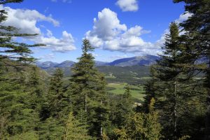
Family walk – Bargemon – La table d’orientation Distance A/R: 9 km Duration A/R: 3h Difficulty: Easy Elevation: 400 m Head past the gendarmerie and follow direction to Col du
Family walk – Bargemon – La table d’orientation Distance A/R: 9 km Duration A/R: 3h Difficulty: Easy Elevation: 400 m Head past the gendarmerie and follow direction to Col du
Family walk – Figanières – La Voie Romaine Distance: 9 km Duration: 3h Difficulty: Easy Elevation: 200 m Parking Saint-Joseph entrance of the village on the left (1). Facing the
Hiking – La Bastide – Le Lachens 332 / 5 000 Résultats de traduction Distance: 11.2 km Duration: 4 hours Difficulty: Difficult Elevation: 800 m (1) Start from La Bastide church.