Sports hike – Draguignan – sentier du patrimoine
Sports hike – Draguignan – sentier du patrimoine Distance A: 6 km Distance B: 3.150 km Duration A/R: 4h Difficulty: Difficult Elevation: 450 m 1st itinerary (1) From Folletiere “wash
Sports hike – Draguignan – sentier du patrimoine Distance A: 6 km Distance B: 3.150 km Duration A/R: 4h Difficulty: Difficult Elevation: 450 m 1st itinerary (1) From Folletiere “wash
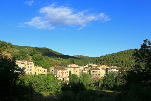
Family walk – Montferrat – Notre Dame de Beauvoir Distance: 2.9 km Duration: 2h / 2h30 Difficulty: Easy Elevation: 250 m Carpark at the entrance of the village, above the
Family walk – Vidauban – Le bois du Rouquan Distance : 4,1 km Duration : 2 h Difficulty: Easy Elevation: 45 m From Vidauban, go onto RD48 to La Garde Freinet